
This past Tuesday I featured the tombstone of Margaret E. “Maggie” (Kallenberger) Hoehamer. Wednesday. while looking through some old photos, I found this cabinet card which had her name written on the back.
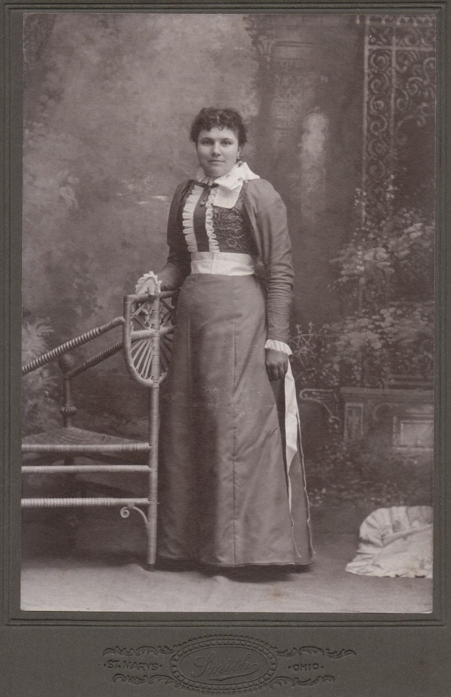
Maggie (Kallenberger) Hoehamer (1874-1950)
This photograph was taken by Smith Photography in St. Marys, Ohio. From the style of her dress and the embellishments on it I would estimate the photo was taken around 1900.
I was able to see some details of the photograph by using a magnifying glass. Maggie was wearing a wedding band so it appears the photo was taken after she and William were married in May 1900. Perhaps this photo was taken on Maggie’s wedding day, in her wedding dress. It was a fancy dress. Notice the lace and bead-work on the bodice as well as the ruffles and bow. She was also wearing jewelry, a necklace and earrings.
Maggie was the daughter of Andrew and Elizabeth (Burkhart) Kallenberger. Their photo below was taken at Morrison Photography in Chattanooga. This is the third photo I have seen from Morrison Photography in Chatt, but I know very little about the studio.
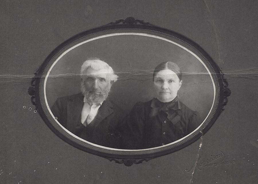
Andrew & Elizabeth (Burkhart) Kallenberger, parents of Maggie.
In 1940 Maggie and William lived northeast of Chattanooga and west of Rockford. Maggie was a housewife and her highest level of education was the 8th grade. Their grandson Ansel Shindeldecker, age 16, was living with them and doing farm labor for them. The Hoehamers were living close to several folks I knew and remember: Kermit, Fern & Bonnie Stetler; Claude, Virginia, Vivian & Shirley Buchanan; Vernon, Donna & Carolyn Caffee; Jesse & Dorthea Pickering; John H., Caroline, Dale & Donald Caffee; Eugene, Dolores & Bobbie Caffee; Charles, Nora, Floyd, Harold & Donald Sipe. These were some of their neighbors as they were enumerated in the census. [1] So interesting!
The Hoehamers lived in the area between Wilson, Manley, Wabash, and Hill Roads, in Section 22 of Blackcreek Township, Mercer County, Ohio. Their farm is #67 on the map below, just to the right of the first “E” in Creek. [2]
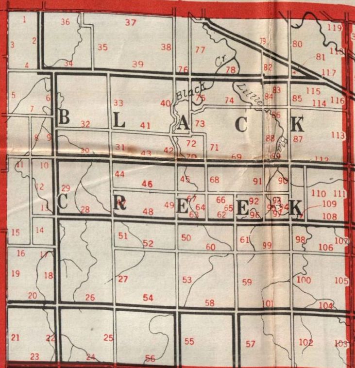
Blackcreek Township, Mercer County, Ohio, 1916 Farm Journal Directory.
[1] 1940 U.S. Census, Blackcreek, Mercer, Ohio, ED 54-1, p.6A, household 118, line 11, W.H. Hoehammer; digital image by subscription, Ancestry.com (www.ancestry.com : accessed 1 August 2013); from National Archives microfilm T627, roll 3114.
[2] The Farm Journal Illustrated Directory of Mercer County, Ohio, 1916 (Philadelphia : Wilmer Atkinson Company, 1919), 99.
7 comments
Skip to comment form
This map is very hard to read. I think i have found the position of plots by locating the creek on my farm which crosses Wilson road at the corner of Wilson and Grauberger. Therefore it appears that the heavy double black line below the word “creek” is Willson Road and the light gray line above the word “creek” is Manley Road. The heavy double black line between “Black” and “Creek” would be Rockfordwest Road. Unfortunately there appear to be too many roads in the immediate area of the ‘E’ in question, roads that are not there.
The comment about ‘neighbors’ is also confusing. Normally one would consider neighbors adjoining locations (let us assume we are not talking Biblical terms here), yet I recognize the names listed as being neighbors only in the sense that they live within a few miles, not next door to the Hoehammer place. Would that be correct?
Author
Note that the map is from the 1916 Mercer County Directory. The “neighbors” I mentioned are from the 1940 census. In the census, the families are listed and numbered in the order that the census taker visited them. The census taker usually went up and down the roads in a methodical way. We don’t know the route the census taker used but you would assume these people lived fairly close together. I have not looked at any land deeds, but did William and Maggie always live in the same location?
By 1940 Vernon Caffee had to already be living on 49 just north of your parents home. Claud Buchanan lived on the stateline on the other side of 49. Kermit and Fern lived much closer to Willshire, but may have moved in that time period shortly after the census in 1940, I simply do not know. John, Dale, Don and Gene Caffee have always lived closer to Chatt, again near your folks farm (several of the farms around your homestead are still their homes today). All of these places are several miles from the “E” in Creek on your map, in fact these homesteads are not even located on that map.
Author
It does appear that the census taker took the long route around the township.
In 1940 the folks were much more mobile and communication still limited (ie few phones, no TV, etc.), so the census taker may have had considerable difficulty in finding folks at home. In 1916 travel was much more limited and one would usually expect someone to be around the farm, but the introduction of the car and tendancy to work away from the farm by 1940 may have easily resulted in the census taker having to travel back and forth the find each family, thus scarmbling the order a bit and enlarging the area of coverage. While the folks you name may not have been next door neighbors, as you note, they knew each other well and many attended church in Chatt. Indeed Caffees, Stetlers, Hoehammers and Kallenbergers were all related (as you have indicated marriages were often within a 3 mile radius).
Author
In 1940 the census enumerator was supposed to write the revisits, the ones he didn’t catch at home the first time, on a separate sheet.
Consulting with older folks who actually visited the Hoehammers in their home, I find that I was mistaken about the farm, it was the one across Manley road (on the North side of the road – small white house) not the one on the South side back the long lane (reportedly the Smalley Farm). Our family call her Aunt Meg, though it is clear some called her Maggie. There seems to have been some stife and health issues that separated “Bill” and “Meg” in the end and other family members took turns staying with Aunt Meg to take care of her.
No one seems to remember the tree in the road. There are some question about a tree in the driveway, etc., but no one can place a tree in the road. Of course even these folks would have been talking about the conditons in the 40s.