
Last week I posted images of pages from the 1910 Quadrennial Assessor’s Report of Blackcreek Township. The booklet belonged to my great-grandfather Jacob Miller who owned an 80 acre farm in Blackcreek Township.
During that time period Ohio was in the process of changing its tax laws, switching from a decennial appraisement of real property (every ten years) to a quadrennial appraisement (every four years). A general appraisement was made in 1910 and another appraisement was to be made in 1914. [1]

1910 Decennial Appraisement. Black Creek Township, Mercer County, Ohio.
Several years ago, while researching at the Mercer County Courthouse, I photographed some images from a much larger hard cover book, “Decennial Appraisement, 1910, Black Creek Township.” This book contains plat maps drawn of each of the township’s 36 sections. It includes the exact same information as the 1910 Quadrennial Assessor’s Report as well as some additional information about the assessment. [2]
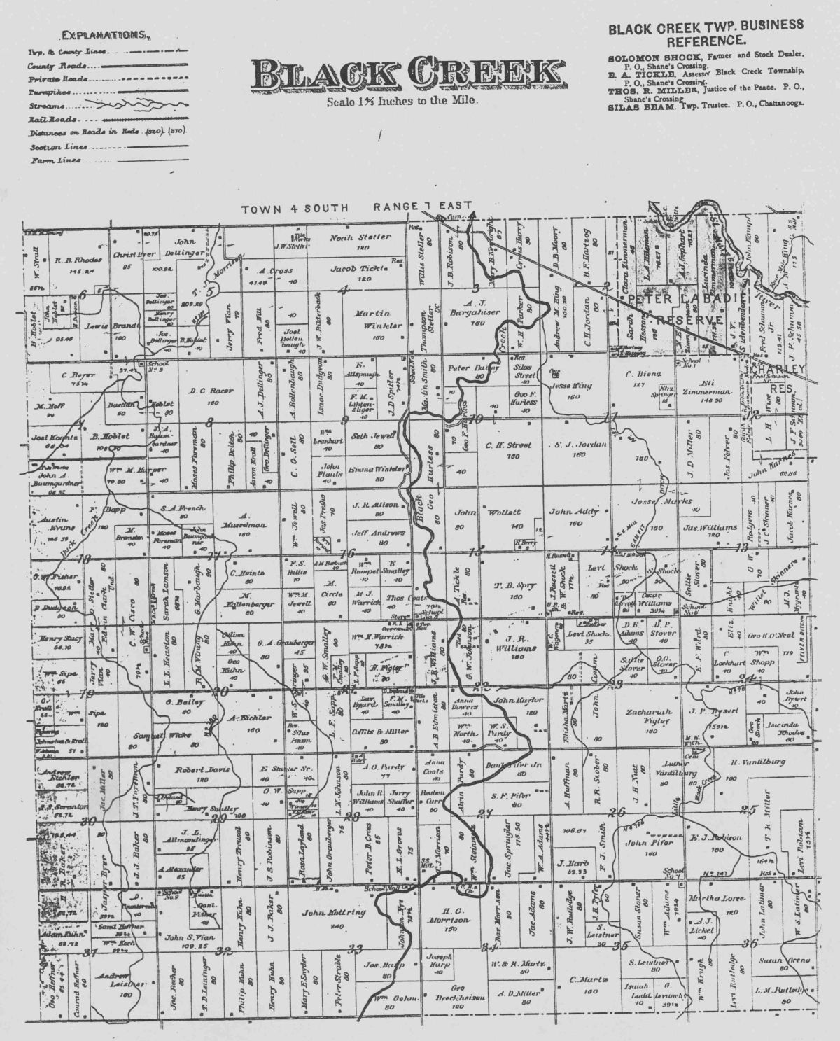
Blackcreek Township, Mercer County, Ohio.
Additional information about the Jacob Miller farm, as recorded in the 1910 Decennial Appraisement:
• He had 63 plowable acres, 7 acres of meadow and pasture land, 10 acres uncultivated & woodland.
• His land was valued at $63 per acre, making a total value of $5040, excluding buildings.
• $88 was deducted for the value of roads
• The Miller home was valued at $800, the barns $500, and other buildings $100, for a total value for lands and buildings of $6352.
• The County Board of Equalization added $50 on land, $0 on buildings, for a total value of $6402, as equalized by the County Board.
• The State Board of Equalization added $1600.50, making a total value of $8002, as equalized by the State Board.
Below are four images from the 1910 Decennial Appraisement of Blackcreek Township, sections 29-32, north of Chatt on either side of Route 49. Sections 30 and 31 border Indiana and are west of State Route 49. Sections 31 and 32 border Liberty Township and are on the north edge of Chatt. Sections 29 and 32 are on the east side of State Route 49.

Section 29 Blackcreek Twp 1910
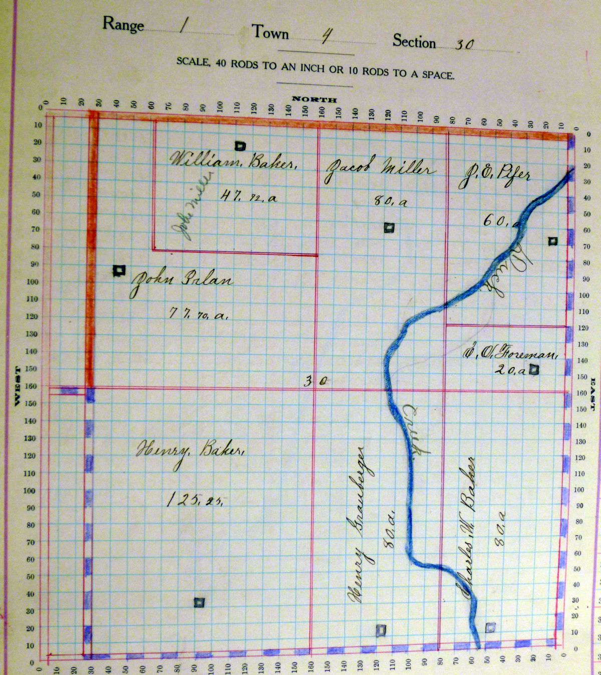
Section 30 Blackcreek Twp 1910
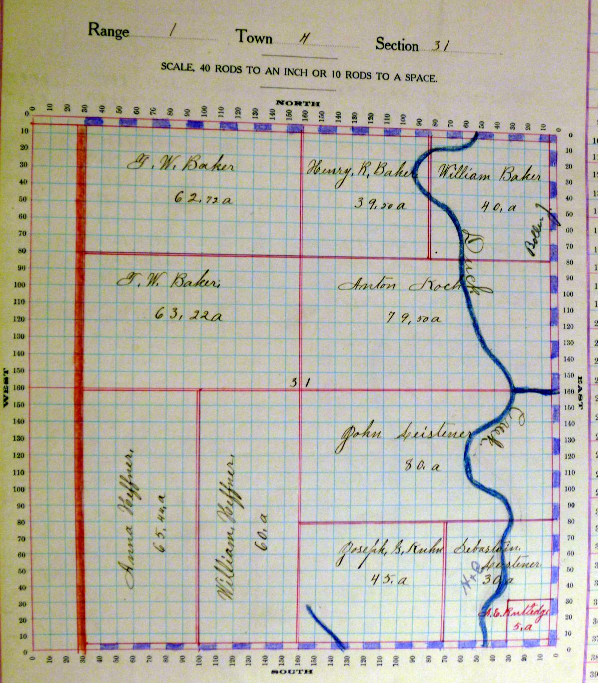
Section 31 Blackcreek Twp 1910
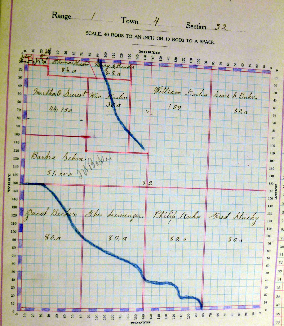
Section 32 Blackcreek Twp 1910
I plan to post all of the section maps on a static page on this website soon.
[1] “Taxation Work and Experience in Ohio,” The Ohio Journal of Commerce, Volume 2, No. 10, 3 September 1910, p.148; Google Books.com (https://books.google.com : accessed 19 March 2015).
[2] Additional columns in the Decennial Appraisement book include: PO address; description of property [legal]; no. of acres classified [broken down as arable and plow land, meadow & pasture land, uncultivated & wood land]; value per acre excluding buildings; deduct value of roads; value of all buildings [broken down as houses, barns, other building]; amount added or deducted by County Board of Equalization on lands; amount added or deducted by County Board of Equalization on buildings; total value as equalized by County Board; amount added or deducted by State Board of Equalization; total value as equalized by State board.
12 comments
Skip to comment form
Cool, Tom’s great grandparents farm, Henry Graubarger’s farm is in Section 30. I will try to make copy and give it to him. I wonder where the White family homestead is. They were all in Blackcreek Twp but I think it was north of Rockford West Road.
Thanks for sharing,
Deb Bollenbacher Reichard
Author
My mom has said that the Graubargers lived west of where I grew up. There was a Martha White who owned 50 acres in Section 18 and Charles White who owned 10 acres in Section 19 in 1910. Are either of those the White you are looking for? I love these old plat maps. The 1876, 1888, and 1900 plat maps have been reprinted so these 1910 maps are a great addition. I plan to eventually put all of the 1910 plat maps on a stationary page on Karen’s Chatt.
Martha White would have been my Great, great Grandmother married to William White. He died in 1920 something and she died in 1940 something. I am assuming the Charles White would have been their oldest son, my Great Grandfather. I believe some of the White’s still live on the Charles White property or near by. My Grandma Martha White Bollenbacher was named after her Grandmother. Thanks for sharing. I will make copies of both Graubarger and White. I have a copy of the Bollenbacher (Jacob nd Carl) from a Mercer Co. book my Dad had.
My grandfather, Howard Caffee, owned the 125 acres shown in two plots just west of Jacob Miller, where my dad, Don Caffee, owns now. I never heard of the person that owned the larger farm. Thank you, Karen, for continuing to post this material. I make copies every week and take it to my parents to read. Dad, especially, really enjoys it.
Author
Yes, so many names that are unfamiliar now. It would be interesting to know when Howard purchased the land and would be easy enough to find out at the Recorder’s Office. I can look it up the next time we go there. In fact, I have copies of many of those index pages. I will look through my stuff and let you know. I may have the information right here at home.
Karen, this is an excellent post. I loved the visual you used, and have to admit that I was not that familiar with decennial appraisements. I have much more to learn!
Author
Thank you, Peggy! I learn so much by writing these posts. Finding those old plat maps at the courthouse was the inspiration.
On the last page you posted I found my family’s piece of land with the name Theo Leininger written You say that these records come from 1910, but Ted did not marry Carrie Becher whose parents originally owned this property until 1919 and he didn’t actually own the land until several decades later. I’m just a bit confused about these dates. How can his name be listed if he didn’t own or work the land until after 1910? Could you clear this up for me?
Author
Hi Doris! Good question that had me puzzled until I checked the 1910 Census, Blackcreek Township. Enumerated on Leininger Pike was a Theobalt Leininger, aged 48, born in Ohio. It looks like his wife’s name was Caroline, age 47, and they had children Edwin A, 18; Bertha C, 15; Samuel J, 12;, and Victor, 5. Some of his neighbors were Jacob Becher, Sarah Kuhn, Fred Stuckey, and those names match the names of the landowners in section 32 on the 1910 map. I would look for some possible Leininger relatives that lived in that area.
I will have to check other plat maps as perhaps I am looking at the wrong area of our family farm. Thanks for your reply.
Author
They may have lived in Liberty Township, not Blackcreek.
I checked my records and you are correct, they did live in Liberty Township. So sorry for not researching this more before I asked the question.